


Pic de Viscos

chasle
User
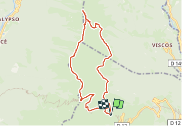

Length
10.5 km

Max alt
2109 m

Uphill gradient
653 m
Km-Effort
19.3 km

Min alt
1679 m

Downhill gradient
654 m
Boucle
Yes
Creation date :
2023-09-28 07:07:17.305
Updated on :
2023-09-28 16:29:56.802
5h47
Difficulty : Difficult

FREE GPS app for hiking
 SityTrail
IGN / Geographical institutes
SityTrail Plus
The world is yours!
About
Trail Walking of 10.5 km to be discovered at Occitania, Hautespyrenees, Grust. This trail is proposed by chasle.
Positioning
Country:
France
Region :
Occitania
Department/Province :
Hautespyrenees
Municipality :
Grust
Location:
Unknown
Start:(Dec)
Start:(UTM)
740028 ; 4753106 (30T) N.
Comments