


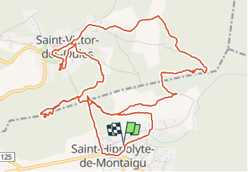
2023.09.28 - St-Hippolyte-de-Montaigu, St-Victor-des-Oules

rando30129
User

Length
9.4 km

Max alt
246 m

Uphill gradient
246 m
Km-Effort
12.7 km

Min alt
136 m

Downhill gradient
245 m
Boucle
Yes
Creation date :
2023-09-28 11:44:31.0
Updated on :
2023-09-28 17:33:42.374
3h43
Difficulty : Unknown

FREE GPS app for hiking
 SityTrail
IGN / Geographical institutes
SityTrail Plus
The world is yours!
About
Trail Trail of 9.4 km to be discovered at Occitania, Gard, Saint-Hippolyte-de-Montaigu. This trail is proposed by rando30129.
Positioning
Country:
France
Region :
Occitania
Department/Province :
Gard
Municipality :
Saint-Hippolyte-de-Montaigu
Location:
Unknown
Start:(Dec)
Start:(UTM)
619578 ; 4876645 (31T) N.
Comments