


Toulon Mont Faron

ARPF
User
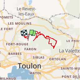

Length
14 km

Max alt
577 m

Uphill gradient
472 m
Km-Effort
20 km

Min alt
372 m

Downhill gradient
469 m
Boucle
Yes
Creation date :
2015-04-06 00:00:00.0
Updated on :
2015-04-06 00:00:00.0
4h30
Difficulty : Medium

FREE GPS app for hiking
 SityTrail
IGN / Geographical institutes
SityTrail Plus
The world is yours!
About
Trail Walking of 14 km to be discovered at Provence-Alpes-Côte d'Azur, Var, Toulon. This trail is proposed by ARPF.
Positioning
Country:
France
Region :
Provence-Alpes-Côte d'Azur
Department/Province :
Var
Municipality :
Toulon
Location:
Unknown
Start:(Dec)
Start:(UTM)
738209 ; 4781267 (31T) N.
Comments
Très belle vue sur la rade et l'Est