


Rebouc g4 2023

LouisROGER
User GUIDE

Length
7.8 km

Max alt
688 m

Uphill gradient
167 m
Km-Effort
10 km

Min alt
575 m

Downhill gradient
167 m
Boucle
Yes
Creation date :
2023-09-29 07:29:02.58
Updated on :
2023-09-29 10:41:43.905
3h12
Difficulty : Medium

FREE GPS app for hiking
 SityTrail
IGN / Geographical institutes
SityTrail Plus
The world is yours!
About
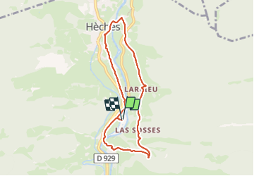
Trail Walking of 7.8 km to be discovered at Occitania, Hautespyrenees, Hèches. This trail is proposed by LouisROGER.
Positioning
Country:
France
Region :
Occitania
Department/Province :
Hautespyrenees
Municipality :
Hèches
Location:
Unknown
Start:(Dec)
Start:(UTM)
286329 ; 4764255 (31T) N.
Comments