


COMBE OYANS

nordan
User
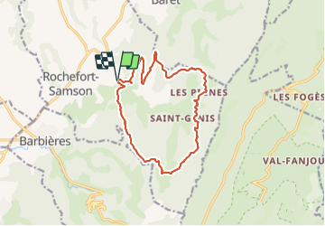

Length
14.4 km

Max alt
879 m

Uphill gradient
766 m
Km-Effort
25 km

Min alt
420 m

Downhill gradient
764 m
Boucle
Yes
Creation date :
2023-09-29 06:39:29.238
Updated on :
2023-09-29 13:49:06.497
4h39
Difficulty : Medium

FREE GPS app for hiking
 SityTrail
IGN / Geographical institutes
SityTrail Plus
The world is yours!
About
Trail Walking of 14.4 km to be discovered at Auvergne-Rhône-Alpes, Drôme, Rochefort-Samson. This trail is proposed by nordan.
Positioning
Country:
France
Region :
Auvergne-Rhône-Alpes
Department/Province :
Drôme
Municipality :
Rochefort-Samson
Location:
Unknown
Start:(Dec)
Start:(UTM)
670946 ; 4982166 (31T) N.
Comments