


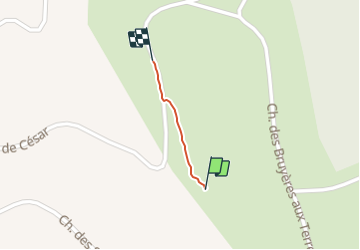
Plan Petit chemin

raymondfn
User

Length
249 m

Max alt
649 m

Uphill gradient
0 m
Km-Effort
265 m

Min alt
636 m

Downhill gradient
5 m
Boucle
No
Creation date :
2023-09-30 09:27:10.0
Updated on :
2023-09-30 09:35:15.959
7m
Difficulty : Medium

FREE GPS app for hiking
 SityTrail
IGN / Geographical institutes
SityTrail Plus
The world is yours!
About
Trail Walking of 249 m to be discovered at Auvergne-Rhône-Alpes, Isère, Plan. This trail is proposed by raymondfn.
Description
Ne débouche pas au retour sur la route !
Positioning
Country:
France
Region :
Auvergne-Rhône-Alpes
Department/Province :
Isère
Municipality :
Plan
Location:
Unknown
Start:(Dec)
Start:(UTM)
688304 ; 5020683 (31T) N.
Comments