


mellecey touche

XavierFaidix
User

Length
8.8 km

Max alt
332 m

Uphill gradient
187 m
Km-Effort
11.3 km

Min alt
205 m

Downhill gradient
188 m
Boucle
Yes
Creation date :
2023-09-30 12:47:55.125
Updated on :
2023-09-30 12:48:42.858
2h34
Difficulty : Easy

FREE GPS app for hiking
 SityTrail
IGN / Geographical institutes
SityTrail Plus
The world is yours!
About
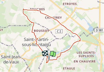
Trail On foot of 8.8 km to be discovered at Bourgogne-Franche-Comté, Saône-et-Loire, Mellecey. This trail is proposed by XavierFaidix.
Positioning
Country:
France
Region :
Bourgogne-Franche-Comté
Department/Province :
Saône-et-Loire
Municipality :
Mellecey
Location:
Unknown
Start:(Dec)
Start:(UTM)
631373 ; 5185325 (31T) N.
Comments