


supergrid

Marie-Hélène Luton 2
User
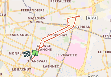

Length
7.5 km

Max alt
187 m

Uphill gradient
49 m
Km-Effort
8.1 km

Min alt
174 m

Downhill gradient
46 m
Boucle
Yes
Creation date :
2023-09-30 14:28:42.351
Updated on :
2023-09-30 16:10:36.8
1h37
Difficulty : Medium

FREE GPS app for hiking
 SityTrail
IGN / Geographical institutes
SityTrail Plus
The world is yours!
About
Trail Walking of 7.5 km to be discovered at Auvergne-Rhône-Alpes, Métropole de Lyon, Lyon. This trail is proposed by Marie-Hélène Luton 2.
Positioning
Country:
France
Region :
Auvergne-Rhône-Alpes
Department/Province :
Métropole de Lyon
Municipality :
Lyon
Location:
Lyon 8e Arrondissement
Start:(Dec)
Start:(UTM)
645847 ; 5066904 (31T) N.
Comments