Trail Walking Maintenon - Le long du Canal Louis XIV à Maintenon - Photo

Le long du Canal Louis XIV à Maintenon

partout a pied et en moto
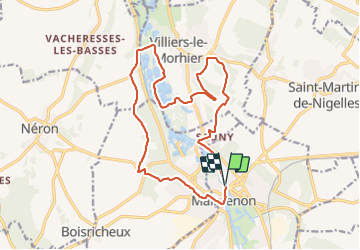
© OpenStreetMap contributors
Length
Length
16.5 km
Max alt
Max alt
144 m
Uphill gradient
Uphill gradient
195 m
Km-Effort
Km-Effort  
19.1 km
Min alt
Min alt
95 m
Downhill gradient
Downhill gradient
194 m
Boucle
Boucle
Yes
Creation date :
2023-09-30 17:26:45.922
Updated on :
2023-09-30 17:28:24.661

(0 Reviews)

Walking
Walking
4h19
Difficulty : Very difficult

Scan this QR Code to open this trail in the SityTrail application

FREE GPS app for hiking

Logo SityTrail SityTrail

IGN / Geographical institutes

Download SityTrail from the App Store Download SityTrail from Google Play

Logo SityTrail SityTrail Plus

The world is yours!

Download SityTrail from the App Store Download SityTrail from Google Play Download SityTrail on Huawei AppGallery

About

Trail Walking of 16.5 km to be discovered at Centre-Loire Valley, Eure-et-Loir, Maintenon. This trail is proposed by les randos d'Olivier.

Elevation profile

Points of interest

Point of interest Maintenon - Place Aristide Briand. Longer le Canal Louis XIV - Photo
olivieraron
Point of interest Pierres - Route D116a - Photo
olivieraron
PIERRES 
Point of interest Pierres - La Mare Vignot - Photo
olivieraron
Point of interest Villiers-le-Morhier - Bifurcation - Photo
olivieraron
VILLIERS-LE-MORHIER 
Point of interest Villiers-le-Morhier - Pommiers - Photo
olivieraron
VILLIERS-LE-MORHIER 
Point of interest Villiers-le-Morhier - Clos-Verdelet - Photo
olivieraron
VILLIERS-LE-MORHIER 
Point of interest Villiers-le-Morhier - GR® 655 - Photo
olivieraron
VILLIERS-LE-MORHIER 
Point of interest Villiers-le-Morhier -  GR® 655 - Photo
olivieraron
VILLIERS-LE-MORHIER 
Point of interest Villiers-le-Morhier - Bifurcation - Photo
olivieraron
VILLIERS-LE-MORHIER 
Point of interest Villiers-le-Morhier - Malmaison - Photo
olivieraron
VILLIERS-LE-MORHIER 
Point of interest Villiers-le-Morhier - Château d’eau - Photo
olivieraron
VILLIERS-LE-MORHIER 
Point of interest Nogent-le-Roi - Route D983 - Photo
olivieraron
NOGENT-LE-ROI 
Point of interest Pierres - Hameau. GRP - Photo
olivieraron
PIERRES 
Point of interest Pierres - Sentier forestier - Photo
olivieraron
Point of interest Pierres - Sente de Saint Piat - Photo
olivieraron
Point of interest Pierres - Sentier GRP - Photo
olivieraron
PIERRES 
Point of interest Maintenon - Route D109 - Photo
olivieraron
MAINTENON 
Point of interest Maintenon - Place Aristide Briand - Photo
olivieraron

Positioning

Country:
France
Region :
Centre-Loire Valley
Department/Province :
Eure-et-Loir
Municipality :
Maintenon
Location:
Unknown
Start:(UTM)
395133 ; 5382844 (31U) N.


Close
My subscriptions