


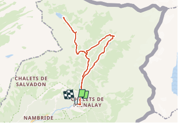
Lac de Voggealle et le bout du mont Sixt Fer à Cheval

GioA10
User

Length
18.8 km

Max alt
2007 m

Uphill gradient
1189 m
Km-Effort
35 km

Min alt
941 m

Downhill gradient
1195 m
Boucle
Yes
Creation date :
2023-09-29 07:40:27.0
Updated on :
2023-09-30 18:29:52.225
8h47
Difficulty : Difficult

FREE GPS app for hiking
 SityTrail
IGN / Geographical institutes
SityTrail Plus
The world is yours!
About
Trail Walking of 18.8 km to be discovered at Auvergne-Rhône-Alpes, Upper Savoy, Sixt-Fer-à-Cheval. This trail is proposed by GioA10.
Positioning
Country:
France
Region :
Auvergne-Rhône-Alpes
Department/Province :
Upper Savoy
Municipality :
Sixt-Fer-à-Cheval
Location:
Unknown
Start:(Dec)
Start:(UTM)
332816 ; 5104913 (32T) N.
Comments