


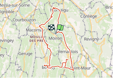
Moiron

cmike39
User

Length
19.5 km

Max alt
574 m

Uphill gradient
546 m
Km-Effort
27 km

Min alt
273 m

Downhill gradient
547 m
Boucle
Yes
Creation date :
2023-09-28 06:57:56.348
Updated on :
2023-10-01 07:25:00.459
4h36
Difficulty : Very difficult

FREE GPS app for hiking
 SityTrail
IGN / Geographical institutes
SityTrail Plus
The world is yours!
About
Trail Walking of 19.5 km to be discovered at Bourgogne-Franche-Comté, Jura, Moiron. This trail is proposed by cmike39.
Positioning
Country:
France
Region :
Bourgogne-Franche-Comté
Department/Province :
Jura
Municipality :
Moiron
Location:
Unknown
Start:(Dec)
Start:(UTM)
696169 ; 5168423 (31T) N.
Comments