


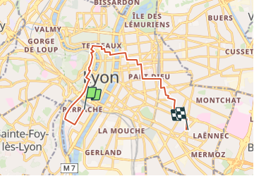
De Place des Archives à Monplaisir

Marie-Hélène Luton 2
User

Length
11.2 km

Max alt
188 m

Uphill gradient
126 m
Km-Effort
12.9 km

Min alt
160 m

Downhill gradient
126 m
Boucle
No
Creation date :
2023-10-01 07:37:14.219
Updated on :
2023-10-01 07:39:35.127
2h55
Difficulty : Difficult

FREE GPS app for hiking
 SityTrail
IGN / Geographical institutes
SityTrail Plus
The world is yours!
About
Trail Walking of 11.2 km to be discovered at Auvergne-Rhône-Alpes, Métropole de Lyon, Lyon. This trail is proposed by Marie-Hélène Luton 2.
Description
Départ de place des archives, poursuite via Confluence, les quais de la Saône, le vieux Lyon, La place des Terreaux, Fort Monluc et retour par place Ambroise Courtois.
Positioning
Country:
France
Region :
Auvergne-Rhône-Alpes
Department/Province :
Métropole de Lyon
Municipality :
Lyon
Location:
Lyon 2e Arrondissement
Start:(Dec)
Start:(UTM)
641901 ; 5067528 (31T) N.
Comments