J3 - Concarneau -Trégunc

Delahalle
User
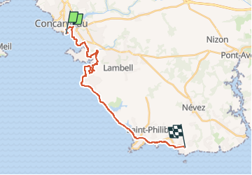

Length
22 km

Max alt
27 m

Uphill gradient
166 m
Km-Effort
24 km

Min alt
-3 m

Downhill gradient
149 m
Boucle
No
Creation date :
2023-10-01 08:11:05.539
Updated on :
2024-07-31 16:01:02.685
6h20
Difficulty : Medium

FREE GPS app for hiking
 SityTrail
IGN / Geographical institutes
SityTrail Plus
The world is yours!
About
Trail Walking of 22 km to be discovered at Brittany, Finistère, Concarneau. This trail is proposed by Delahalle.

Positioning
Country:
France
Region :
Brittany
Department/Province :
Finistère
Municipality :
Concarneau
Location:
Unknown
Start:(Dec)
Start:(UTM)
431415 ; 5302092 (30T) N.
Comments