


st Romain de Cbosc

RoMo
User
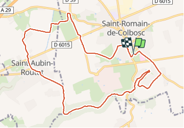

Length
11.7 km

Max alt
125 m

Uphill gradient
132 m
Km-Effort
13.5 km

Min alt
68 m

Downhill gradient
132 m
Boucle
Yes
Creation date :
2023-10-01 07:00:42.707
Updated on :
2023-10-01 10:32:52.927
2h38
Difficulty : Easy

FREE GPS app for hiking
 SityTrail
IGN / Geographical institutes
SityTrail Plus
The world is yours!
About
Trail Walking of 11.7 km to be discovered at Normandy, Seine-Maritime, Saint-Romain-de-Colbosc. This trail is proposed by RoMo.
Description
Boucle
Positioning
Country:
France
Region :
Normandy
Department/Province :
Seine-Maritime
Municipality :
Saint-Romain-de-Colbosc
Location:
Unknown
Start:(Dec)
Start:(UTM)
308976 ; 5489229 (31U) N.
Comments