


Saint Martin de Brôme

darranger
User
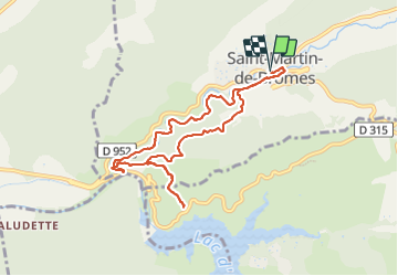

Length
9.4 km

Max alt
449 m

Uphill gradient
213 m
Km-Effort
12.3 km

Min alt
315 m

Downhill gradient
213 m
Boucle
Yes
Creation date :
2023-10-01 08:07:18.461
Updated on :
2023-10-01 13:48:39.198
2h59
Difficulty : Difficult

FREE GPS app for hiking
 SityTrail
IGN / Geographical institutes
SityTrail Plus
The world is yours!
About
Trail Walking of 9.4 km to be discovered at Provence-Alpes-Côte d'Azur, Alpes-de-Haute-Provence, Saint-Martin-de-Brômes. This trail is proposed by darranger.
Positioning
Country:
France
Region :
Provence-Alpes-Côte d'Azur
Department/Province :
Alpes-de-Haute-Provence
Municipality :
Saint-Martin-de-Brômes
Location:
Unknown
Start:(Dec)
Start:(UTM)
737074 ; 4850449 (31T) N.
Comments