


Chapelle Saint Pierre Peyrus

meillon
User
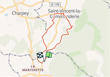

Length
7.2 km

Max alt
455 m

Uphill gradient
167 m
Km-Effort
9.5 km

Min alt
341 m

Downhill gradient
167 m
Boucle
Yes
Creation date :
2023-10-01 11:21:17.317
Updated on :
2023-10-01 14:05:51.037
2h44
Difficulty : Easy

FREE GPS app for hiking
 SityTrail
IGN / Geographical institutes
SityTrail Plus
The world is yours!
About
Trail Walking of 7.2 km to be discovered at Auvergne-Rhône-Alpes, Drôme, Peyrus. This trail is proposed by meillon.
Description
par Saint Vincent de la commanderie
Positioning
Country:
France
Region :
Auvergne-Rhône-Alpes
Department/Province :
Drôme
Municipality :
Peyrus
Location:
Unknown
Start:(Dec)
Start:(UTM)
666276 ; 4976172 (31T) N.
Comments