


Borrys

ARPF1
User

Length
16.5 km

Max alt
721 m

Uphill gradient
652 m
Km-Effort
25 km

Min alt
153 m

Downhill gradient
652 m
Boucle
Yes
Creation date :
2023-10-01 06:51:23.684
Updated on :
2023-10-02 07:36:02.701
4h32
Difficulty : Difficult

FREE GPS app for hiking
 SityTrail
IGN / Geographical institutes
SityTrail Plus
The world is yours!
About
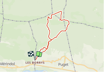
Trail Walking of 16.5 km to be discovered at Provence-Alpes-Côte d'Azur, Vaucluse, Puget. This trail is proposed by ARPF1.
Positioning
Country:
France
Region :
Provence-Alpes-Côte d'Azur
Department/Province :
Vaucluse
Municipality :
Puget
Location:
Unknown
Start:(Dec)
Start:(UTM)
679988 ; 4847486 (31T) N.
Comments