


Entre le Canal Louis XIV et la Vallée de l'Eure

olivieraron
User
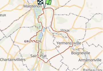

Length
16.9 km

Max alt
155 m

Uphill gradient
194 m
Km-Effort
19.4 km

Min alt
100 m

Downhill gradient
194 m
Boucle
Yes
Creation date :
2023-10-02 16:55:26.31
Updated on :
2023-10-02 17:36:48.11

FREE GPS app for hiking
 SityTrail
IGN / Geographical institutes
SityTrail Plus
The world is yours!
About
Trail of 16.9 km to be discovered at Centre-Loire Valley, Eure-et-Loir, Maintenon. This trail is proposed by olivieraron.
Points of interest


Positioning
Country:
France
Region :
Centre-Loire Valley
Department/Province :
Eure-et-Loir
Municipality :
Maintenon
Location:
Unknown
Start:(Dec)
Start:(UTM)
396152 ; 5382260 (31U) N.
Comments