


Laurentides - Mont Tremblant.

clbertrand@skynet.be
User
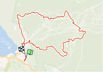

Length
14.7 km

Max alt
872 m

Uphill gradient
655 m
Km-Effort
23 km

Min alt
226 m

Downhill gradient
658 m
Boucle
Yes
Creation date :
2023-10-02 14:21:40.0
Updated on :
2023-10-28 19:58:10.053
5h19
Difficulty : Medium

FREE GPS app for hiking
 SityTrail
IGN / Geographical institutes
SityTrail Plus
The world is yours!
About
Trail Walking of 14.7 km to be discovered at Quebec, Les Laurentides, Mont-Tremblant. This trail is proposed by clbertrand@skynet.be.
Positioning
Country:
Canada
Region :
Quebec
Department/Province :
Les Laurentides
Municipality :
Mont-Tremblant
Location:
Unknown
Start:(Dec)
Start:(UTM)
532122 ; 5117145 (18T) N.
Comments