


col_deze-16796730-1696408405-963

topolino
User
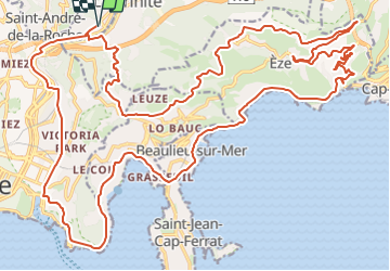

Length
39 km

Max alt
543 m

Uphill gradient
968 m
Km-Effort
52 km

Min alt
5 m

Downhill gradient
968 m
Boucle
Yes
Creation date :
2023-10-04 08:33:58.223
Updated on :
2023-10-04 08:40:04.338
3h09
Difficulty : Very difficult

FREE GPS app for hiking
 SityTrail
IGN / Geographical institutes
SityTrail Plus
The world is yours!
About
Trail Road bike of 39 km to be discovered at Provence-Alpes-Côte d'Azur, Maritime Alps, Nice. This trail is proposed by topolino.
Positioning
Country:
France
Region :
Provence-Alpes-Côte d'Azur
Department/Province :
Maritime Alps
Municipality :
Nice
Location:
Unknown
Start:(Dec)
Start:(UTM)
363481 ; 4844120 (32T) N.
Comments