


Boucle St Baume Huveaune

kephas
User
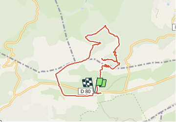

Length
9.9 km

Max alt
771 m

Uphill gradient
428 m
Km-Effort
15.6 km

Min alt
431 m

Downhill gradient
428 m
Boucle
Yes
Creation date :
2023-10-04 09:02:39.77
Updated on :
2023-10-04 14:56:14.806
5h52
Difficulty : Medium

FREE GPS app for hiking
 SityTrail
IGN / Geographical institutes
SityTrail Plus
The world is yours!
About
Trail Walking of 9.9 km to be discovered at Provence-Alpes-Côte d'Azur, Var, Plan-d'Aups-Sainte-Baume. This trail is proposed by kephas.
Description
Une descente abrupte
Photos


Positioning
Country:
France
Region :
Provence-Alpes-Côte d'Azur
Department/Province :
Var
Municipality :
Plan-d'Aups-Sainte-Baume
Location:
Unknown
Start:(Dec)
Start:(UTM)
723360 ; 4801754 (31T) N.
Comments