


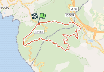
Trail(13) - Cap Canaille

HG74250
User

Length
9.9 km

Max alt
323 m

Uphill gradient
302 m
Km-Effort
13.9 km

Min alt
118 m

Downhill gradient
300 m
Boucle
Yes
Creation date :
2023-10-04 17:52:57.477
Updated on :
2023-10-04 17:54:20.211
0m
Difficulty : Easy

FREE GPS app for hiking
 SityTrail
IGN / Geographical institutes
SityTrail Plus
The world is yours!
About
Trail Running of 9.9 km to be discovered at Provence-Alpes-Côte d'Azur, Bouches-du-Rhône, Cassis. This trail is proposed by HG74250.
Positioning
Country:
France
Region :
Provence-Alpes-Côte d'Azur
Department/Province :
Bouches-du-Rhône
Municipality :
Cassis
Location:
Unknown
Start:(Dec)
Start:(UTM)
708061 ; 4787043 (31T) N.
Comments