


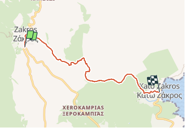
C Zachros Katos Zachros par E4 et Gorges des morts

HAL26
User

Length
6.8 km

Max alt
221 m

Uphill gradient
163 m
Km-Effort
9.7 km

Min alt
-1 m

Downhill gradient
368 m
Boucle
No
Creation date :
2023-10-05 06:22:15.391
Updated on :
2023-10-05 08:09:02.05
1h46
Difficulty : Easy

FREE GPS app for hiking
 SityTrail
IGN / Geographical institutes
SityTrail Plus
The world is yours!
About
Trail Walking of 6.8 km to be discovered at Region of Crete, Lasithi Regional Unit, Municipality of Zakros. This trail is proposed by HAL26.
Positioning
Country:
Greece
Region :
Region of Crete
Department/Province :
Lasithi Regional Unit
Municipality :
Municipality of Zakros
Location:
Unknown
Start:(Dec)
Start:(UTM)
428722 ; 3885454 (35S) N.
Comments