


marvelise

jacthiry
User
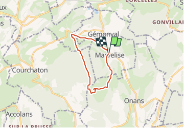

Length
8.9 km

Max alt
513 m

Uphill gradient
256 m
Km-Effort
12.3 km

Min alt
350 m

Downhill gradient
257 m
Boucle
Yes
Creation date :
2023-10-05 12:04:21.615
Updated on :
2023-10-05 14:57:17.745
2h21
Difficulty : Difficult

FREE GPS app for hiking
 SityTrail
IGN / Geographical institutes
SityTrail Plus
The world is yours!
About
Trail Walking of 8.9 km to be discovered at Bourgogne-Franche-Comté, Doubs, Marvelise. This trail is proposed by jacthiry.
Positioning
Country:
France
Region :
Bourgogne-Franche-Comté
Department/Province :
Doubs
Municipality :
Marvelise
Location:
Unknown
Start:(Dec)
Start:(UTM)
318761 ; 5266134 (32T) N.
Comments