


la mutuelle depuis savel plage

starco
User
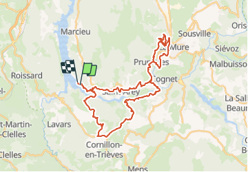

Length
42 km

Max alt
1152 m

Uphill gradient
1733 m
Km-Effort
65 km

Min alt
470 m

Downhill gradient
1727 m
Boucle
No
Creation date :
2023-10-06 07:33:13.464
Updated on :
2023-10-06 10:55:38.436
3h21
Difficulty : Difficult

FREE GPS app for hiking
 SityTrail
IGN / Geographical institutes
SityTrail Plus
The world is yours!
About
Trail Mountain bike of 42 km to be discovered at Auvergne-Rhône-Alpes, Isère, Mayres-Savel. This trail is proposed by starco.
Positioning
Country:
France
Region :
Auvergne-Rhône-Alpes
Department/Province :
Isère
Municipality :
Mayres-Savel
Location:
Unknown
Start:(Dec)
Start:(UTM)
712767 ; 4972808 (31T) N.
Comments