


Graffigny sortie d’école

charpe
User
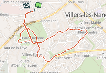

Length
3.2 km

Max alt
296 m

Uphill gradient
97 m
Km-Effort
4.5 km

Min alt
232 m

Downhill gradient
95 m
Boucle
Yes
Creation date :
2023-10-06 14:19:27.0
Updated on :
2023-10-06 15:12:53.838
53m
Difficulty : Easy

FREE GPS app for hiking
 SityTrail
IGN / Geographical institutes
SityTrail Plus
The world is yours!
About
Trail Walking of 3.2 km to be discovered at Grand Est, Meurthe-et-Moselle, Villers-lès-Nancy. This trail is proposed by charpe.
Positioning
Country:
France
Region :
Grand Est
Department/Province :
Meurthe-et-Moselle
Municipality :
Villers-lès-Nancy
Location:
Unknown
Start:(Dec)
Start:(UTM)
289884 ; 5395088 (32U) N.
Comments