


xc 231006 Maroc montagne

xc
User

Length
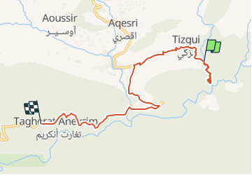
9.8 km

Max alt
823 m

Uphill gradient
193 m
Km-Effort
12.9 km

Min alt
538 m

Downhill gradient
353 m
Boucle
No
Creation date :
2023-10-06 13:25:31.154
Updated on :
2023-10-06 19:00:04.827
5h33
Difficulty : Difficult

FREE GPS app for hiking
 SityTrail
IGN / Geographical institutes
SityTrail Plus
The world is yours!
About
Trail Walking of 9.8 km to be discovered at Souss-Massa, cercle d'Agadir-Atlantique, Aqesri. This trail is proposed by xc.
Positioning
Country:
Morocco
Region :
Souss-Massa
Department/Province :
cercle d'Agadir-Atlantique
Municipality :
Aqesri
Location:
Unknown
Start:(Dec)
Start:(UTM)
454153 ; 3386494 (29R) N.
Comments