


Chatillon en Diois Le Mayor 280923 MCL N3

Joel26400
User
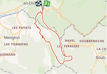

Length
16.1 km

Max alt
1487 m

Uphill gradient
1228 m
Km-Effort
32 km

Min alt
599 m

Downhill gradient
1232 m
Boucle
Yes
Creation date :
2023-10-07 17:00:45.848
Updated on :
2023-10-07 17:00:45.848
7h22
Difficulty : Difficult

FREE GPS app for hiking
 SityTrail
IGN / Geographical institutes
SityTrail Plus
The world is yours!
About
Trail On foot of 16.1 km to be discovered at Auvergne-Rhône-Alpes, Drôme, Châtillon-en-Diois. This trail is proposed by Joel26400.
Positioning
Country:
France
Region :
Auvergne-Rhône-Alpes
Department/Province :
Drôme
Municipality :
Châtillon-en-Diois
Location:
Châtillon-en-Diois
Start:(Dec)
Start:(UTM)
698056 ; 4951259 (31T) N.
Comments