


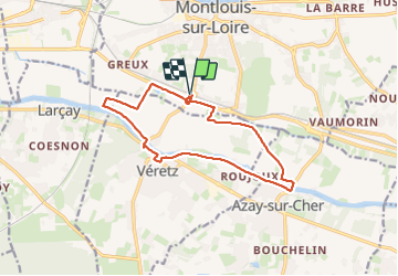
Montlouis-sur-Loire - gare GR41 Veretz Azay-sur-Cher - 13km 85m 2h45 - 2023 10 07

Orcal37
User GUIDE

Length
13 km

Max alt
74 m

Uphill gradient
87 m
Km-Effort
14.2 km

Min alt
45 m

Downhill gradient
87 m
Boucle
Yes
Creation date :
2023-10-07 13:37:54.551
Updated on :
2023-10-08 13:20:50.742
2h45
Difficulty : Easy

FREE GPS app for hiking
 SityTrail
IGN / Geographical institutes
SityTrail Plus
The world is yours!
About
Trail Walking of 13 km to be discovered at Centre-Loire Valley, Indre-et-Loire, Montlouis-sur-Loire. This trail is proposed by Orcal37.
Description
Montlouis-sur-Loire - départ de la gare - la plaine - GR41 - le Cher - Veretz - Azay-sur-Cher - 13km 85m 2h45 - 2023 10 07
Photos


Positioning
Country:
France
Region :
Centre-Loire Valley
Department/Province :
Indre-et-Loire
Municipality :
Montlouis-sur-Loire
Location:
Unknown
Start:(Dec)
Start:(UTM)
335361 ; 5248756 (31T) N.
Comments