


2023-10-07_20h54m08_Mont_Sainr_Odile

anniston
User
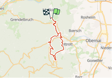

Length
23 km

Max alt
732 m

Uphill gradient
774 m
Km-Effort
33 km

Min alt
279 m

Downhill gradient
774 m
Boucle
No
Creation date :
2023-10-07 18:54:08.569
Updated on :
2023-10-07 18:54:12.307

FREE GPS app for hiking
 SityTrail
IGN / Geographical institutes
SityTrail Plus
The world is yours!
About
Trail of 23 km to be discovered at Grand Est, Bas-Rhin, Rosheim. This trail is proposed by anniston.
Positioning
Country:
France
Region :
Grand Est
Department/Province :
Bas-Rhin
Municipality :
Rosheim
Location:
Unknown
Start:(Dec)
Start:(UTM)
381166 ; 5372523 (32U) N.
Comments