


Décines - lac de Jonage

Marie-Hélène Luton 2
User
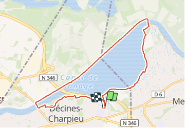

Length
9.6 km

Max alt
205 m

Uphill gradient
64 m
Km-Effort
10.5 km

Min alt
178 m

Downhill gradient
64 m
Boucle
Yes
Creation date :
2023-10-08 08:07:22.993
Updated on :
2023-10-08 10:38:09.772
2h29
Difficulty : Medium

FREE GPS app for hiking
 SityTrail
IGN / Geographical institutes
SityTrail Plus
The world is yours!
About
Trail Walking of 9.6 km to be discovered at Auvergne-Rhône-Alpes, Métropole de Lyon, Décines-Charpieu. This trail is proposed by Marie-Hélène Luton 2.
Positioning
Country:
France
Region :
Auvergne-Rhône-Alpes
Department/Province :
Métropole de Lyon
Municipality :
Décines-Charpieu
Location:
Unknown
Start:(Dec)
Start:(UTM)
653664 ; 5070943 (31T) N.
Comments