


Meyrueix

denis48230
User
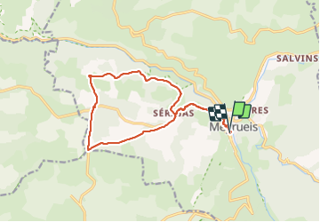

Length
15.8 km

Max alt
972 m

Uphill gradient
452 m
Km-Effort
22 km

Min alt
704 m

Downhill gradient
449 m
Boucle
Yes
Creation date :
2023-10-08 08:10:27.427
Updated on :
2023-10-08 14:32:46.368
6h20
Difficulty : Very difficult

FREE GPS app for hiking
 SityTrail
IGN / Geographical institutes
SityTrail Plus
The world is yours!
About
Trail Walking of 15.8 km to be discovered at Occitania, Lozère, Meyrueis. This trail is proposed by denis48230.
Positioning
Country:
France
Region :
Occitania
Department/Province :
Lozère
Municipality :
Meyrueis
Location:
Unknown
Start:(Dec)
Start:(UTM)
534294 ; 4891558 (31T) N.
Comments