


sjc etape

erisel
User
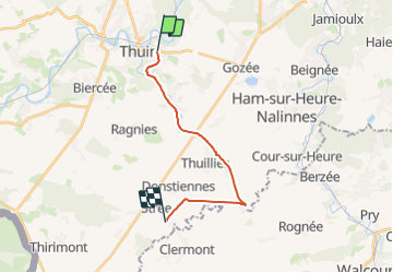

Length
13.3 km

Max alt
188 m

Uphill gradient
121 m
Km-Effort
15 km

Min alt
134 m

Downhill gradient
129 m
Boucle
No
Creation date :
2023-10-08 14:57:33.389
Updated on :
2023-10-08 14:58:49.468
3h24
Difficulty : Difficult

FREE GPS app for hiking
 SityTrail
IGN / Geographical institutes
SityTrail Plus
The world is yours!
About
Trail Walking of 13.3 km to be discovered at Wallonia, Hainaut, Thuin. This trail is proposed by erisel.
Positioning
Country:
Belgium
Region :
Wallonia
Department/Province :
Hainaut
Municipality :
Thuin
Location:
Unknown
Start:(Dec)
Start:(UTM)
592430 ; 5577227 (31U) N.
Comments