


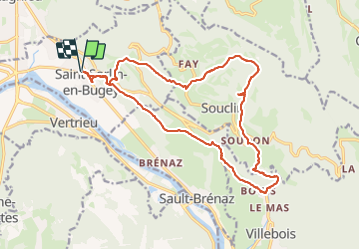
Saint-Sorlin-en-Bugey (19 km-D. 740 m)

Thomasdanielle
User

Length
19 km

Max alt
779 m

Uphill gradient
737 m
Km-Effort
29 km

Min alt
202 m

Downhill gradient
737 m
Boucle
Yes
Creation date :
2023-10-09 07:23:21.0
Updated on :
2023-10-09 17:12:09.678
6h33
Difficulty : Very difficult

FREE GPS app for hiking
 SityTrail
IGN / Geographical institutes
SityTrail Plus
The world is yours!
About
Trail Walking of 19 km to be discovered at Auvergne-Rhône-Alpes, Ain, Saint-Sorlin-en-Bugey. This trail is proposed by Thomasdanielle.
Description
D/A : Parking qui se trouve avant celui de l'école
Belle randonnée mais très difficile
Positioning
Country:
France
Region :
Auvergne-Rhône-Alpes
Department/Province :
Ain
Municipality :
Saint-Sorlin-en-Bugey
Location:
Unknown
Start:(Dec)
Start:(UTM)
683891 ; 5084004 (31T) N.
Comments