


le col vert

MICDURAND
User
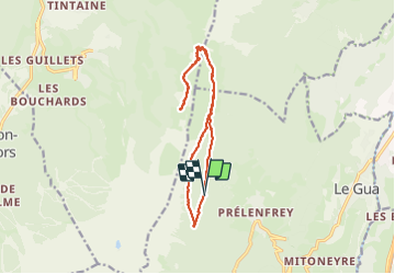

Length
14.6 km

Max alt
1757 m

Uphill gradient
835 m
Km-Effort
26 km

Min alt
1284 m

Downhill gradient
842 m
Boucle
Yes
Creation date :
2023-10-10 06:58:52.796
Updated on :
2023-10-10 13:45:18.737
4h20
Difficulty : Medium

FREE GPS app for hiking
 SityTrail
IGN / Geographical institutes
SityTrail Plus
The world is yours!
About
Trail Walking of 14.6 km to be discovered at Auvergne-Rhône-Alpes, Isère, Le Gua. This trail is proposed by MICDURAND.
Positioning
Country:
France
Region :
Auvergne-Rhône-Alpes
Department/Province :
Isère
Municipality :
Le Gua
Location:
Unknown
Start:(Dec)
Start:(UTM)
704666 ; 4988486 (31T) N.
Comments