


port en bessin

darobes
User
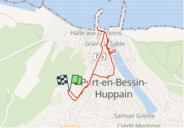

Length
1.8 km

Max alt
19 m

Uphill gradient
16 m
Km-Effort
2.1 km

Min alt
1 m

Downhill gradient
16 m
Boucle
Yes
Creation date :
2023-10-10 14:58:15.678
Updated on :
2023-10-10 15:46:44.175
48m
Difficulty : Easy

FREE GPS app for hiking
 SityTrail
IGN / Geographical institutes
SityTrail Plus
The world is yours!
About
Trail Walking of 1.8 km to be discovered at Normandy, Calvados, Port-en-Bessin-Huppain. This trail is proposed by darobes.
Positioning
Country:
France
Region :
Normandy
Department/Province :
Calvados
Municipality :
Port-en-Bessin-Huppain
Location:
Unknown
Start:(Dec)
Start:(UTM)
662791 ; 5468337 (30U) N.
Comments