


LantriacVelay

taguette
User
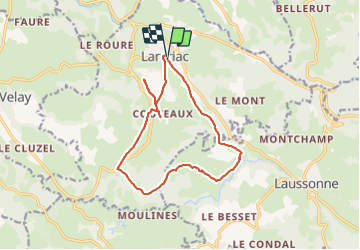

Length
14.5 km

Max alt
975 m

Uphill gradient
347 m
Km-Effort
19.1 km

Min alt
729 m

Downhill gradient
347 m
Boucle
Yes
Creation date :
2023-10-11 08:23:31.181
Updated on :
2023-10-11 11:48:23.793
3h16
Difficulty : Medium

FREE GPS app for hiking
 SityTrail
IGN / Geographical institutes
SityTrail Plus
The world is yours!
About
Trail Walking of 14.5 km to be discovered at Auvergne-Rhône-Alpes, Haute-Loire, Lantriac. This trail is proposed by taguette.
Positioning
Country:
France
Region :
Auvergne-Rhône-Alpes
Department/Province :
Haute-Loire
Municipality :
Lantriac
Location:
Unknown
Start:(Dec)
Start:(UTM)
579256 ; 4983435 (31T) N.
Comments