


Klingenthal - tour du Mont Sainte Odile

anniston
User
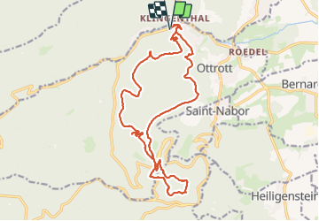

Length
19.2 km

Max alt
831 m

Uphill gradient
640 m
Km-Effort
28 km

Min alt
304 m

Downhill gradient
639 m
Boucle
Yes
Creation date :
2023-10-11 10:45:14.326
Updated on :
2023-10-12 08:50:30.498
3h38
Difficulty : Medium

FREE GPS app for hiking
 SityTrail
IGN / Geographical institutes
SityTrail Plus
The world is yours!
About
Trail Horseback riding of 19.2 km to be discovered at Grand Est, Bas-Rhin, Ottrott. This trail is proposed by anniston.
Positioning
Country:
France
Region :
Grand Est
Department/Province :
Bas-Rhin
Municipality :
Ottrott
Location:
Unknown
Start:(Dec)
Start:(UTM)
382179 ; 5369437 (32U) N.
Comments