


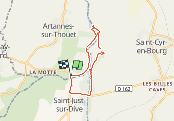
MAINE ET LOIRE / ARTANNES: GATINES

djeepee74
User

Length
5.6 km

Max alt
49 m

Uphill gradient
46 m
Km-Effort
6.2 km

Min alt
24 m

Downhill gradient
45 m
Boucle
Yes
Creation date :
2023-10-12 13:27:55.439
Updated on :
2023-10-16 18:54:21.744
1h24
Difficulty : Easy

FREE GPS app for hiking
 SityTrail
IGN / Geographical institutes
SityTrail Plus
The world is yours!
About
Trail Walking of 5.6 km to be discovered at Pays de la Loire, Maine-et-Loire, Artannes-sur-Thouet. This trail is proposed by djeepee74.
Description
BOUCLE... live du 20231012
Positioning
Country:
France
Region :
Pays de la Loire
Department/Province :
Maine-et-Loire
Municipality :
Artannes-sur-Thouet
Location:
Unknown
Start:(Dec)
Start:(UTM)
720466 ; 5230154 (30T) N.
Comments