


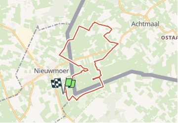
Grenswandeling Nieuwmoer De Maatjes

LucThomaere
User


3h38
Difficulty : Medium

FREE GPS app for hiking
 SityTrail
IGN / Geographical institutes
SityTrail Plus
The world is yours!
About
Trail Walking of 15.2 km to be discovered at Flanders, Antwerp, Kalmthout. This trail is proposed by LucThomaere.
Description
Vertrek: De Maatjes, Wiewaustraat Wuustwezel/Nieuwmoer.
Wandeling door het landbouwgebied van Nieuwmoer/Wuustwezel. Enkel wat boerderijen tegenkomen, het kan hier nog.
Slechts enkele stukken waar ook auto's komen, meestal onverharde wegen en soms een grasweg.
Heel mooie wandeling!
Positioning
Comments