


v mont

micheleuvrard
User

Length
31 km

Max alt
439 m

Uphill gradient
567 m
Km-Effort
38 km

Min alt
186 m

Downhill gradient
566 m
Boucle
Yes
Creation date :
2023-10-14 12:21:55.582
Updated on :
2023-10-14 14:30:17.186
2h08
Difficulty : Difficult

FREE GPS app for hiking
 SityTrail
IGN / Geographical institutes
SityTrail Plus
The world is yours!
About
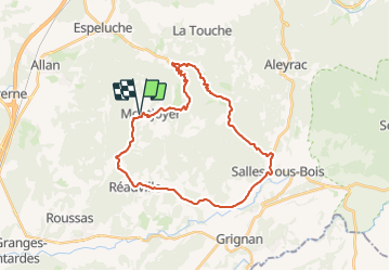
Trail Road bike of 31 km to be discovered at Auvergne-Rhône-Alpes, Drôme, Montjoyer. This trail is proposed by micheleuvrard.
Positioning
Country:
France
Region :
Auvergne-Rhône-Alpes
Department/Province :
Drôme
Municipality :
Montjoyer
Location:
Unknown
Start:(Dec)
Start:(UTM)
646878 ; 4926507 (31T) N.
Comments