


circuit étang chapitre

Alain Gasnot
User
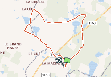

Length
9.2 km

Max alt
119 m

Uphill gradient
65 m
Km-Effort
10 km

Min alt
94 m

Downhill gradient
66 m
Boucle
Yes
Creation date :
2023-10-15 08:47:07.087
Updated on :
2023-10-15 10:33:23.035
1h45
Difficulty : Easy

FREE GPS app for hiking
 SityTrail
IGN / Geographical institutes
SityTrail Plus
The world is yours!
About
Trail Mountain bike of 9.2 km to be discovered at Centre-Loire Valley, Loir-et-Cher, Mur-de-Sologne. This trail is proposed by Alain Gasnot.
Positioning
Country:
France
Region :
Centre-Loire Valley
Department/Province :
Loir-et-Cher
Municipality :
Mur-de-Sologne
Location:
Unknown
Start:(Dec)
Start:(UTM)
392378 ; 5248980 (31T) N.
Comments