


Orcines Ternant

Papou63patrick
User
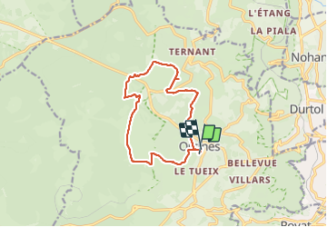

Length
12.3 km

Max alt
1009 m

Uphill gradient
256 m
Km-Effort
15.7 km

Min alt
832 m

Downhill gradient
260 m
Boucle
Yes
Creation date :
2023-10-15 07:46:46.12
Updated on :
2023-10-15 11:14:56.88
3h27
Difficulty : Easy

FREE GPS app for hiking
 SityTrail
IGN / Geographical institutes
SityTrail Plus
The world is yours!
About
Trail Walking of 12.3 km to be discovered at Auvergne-Rhône-Alpes, Puy-de-Dôme, Orcines. This trail is proposed by Papou63patrick.
Photos

Positioning
Country:
France
Region :
Auvergne-Rhône-Alpes
Department/Province :
Puy-de-Dôme
Municipality :
Orcines
Location:
Unknown
Start:(Dec)
Start:(UTM)
500888 ; 5069972 (31T) N.
Comments