


Rocher de Mirouge

lebarça
User

Length
13.2 km

Max alt
1418 m

Uphill gradient
835 m
Km-Effort
24 km

Min alt
601 m

Downhill gradient
835 m
Boucle
Yes
Creation date :
2023-10-15 07:03:36.0
Updated on :
2023-10-18 16:19:07.786
5h31
Difficulty : Very easy

FREE GPS app for hiking
 SityTrail
IGN / Geographical institutes
SityTrail Plus
The world is yours!
About
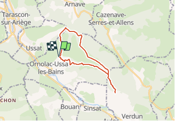
Trail Walking of 13.2 km to be discovered at Occitania, Ariège, Ornolac-Ussat-les-Bains. This trail is proposed by lebarça.
Positioning
Country:
France
Region :
Occitania
Department/Province :
Ariège
Municipality :
Ornolac-Ussat-les-Bains
Location:
Unknown
Start:(Dec)
Start:(UTM)
388625 ; 4742329 (31T) N.
Comments