


St Romain de Colbosc circuit bleu

DDLEDANDY
User
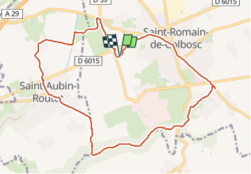

Length
10.4 km

Max alt
126 m

Uphill gradient
121 m
Km-Effort
12.1 km

Min alt
68 m

Downhill gradient
122 m
Boucle
Yes
Creation date :
2023-10-17 06:44:27.014
Updated on :
2023-10-17 09:25:18.712
2h39
Difficulty : Very easy

FREE GPS app for hiking
 SityTrail
IGN / Geographical institutes
SityTrail Plus
The world is yours!
About
Trail Nordic walking of 10.4 km to be discovered at Normandy, Seine-Maritime, Saint-Romain-de-Colbosc. This trail is proposed by DDLEDANDY.
Positioning
Country:
France
Region :
Normandy
Department/Province :
Seine-Maritime
Municipality :
Saint-Romain-de-Colbosc
Location:
Unknown
Start:(Dec)
Start:(UTM)
307814 ; 5489586 (31U) N.
Comments