


Puech Pezoul

ARVIEU
User

Length
12.5 km

Max alt
222 m

Uphill gradient
265 m
Km-Effort
16.1 km

Min alt
107 m

Downhill gradient
265 m
Boucle
Yes
Creation date :
2015-02-08 00:00:00.0
Updated on :
2015-02-08 00:00:00.0
3h28
Difficulty : Medium

FREE GPS app for hiking
 SityTrail
IGN / Geographical institutes
SityTrail Plus
The world is yours!
About
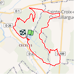
Trail Walking of 12.5 km to be discovered at Occitania, Hérault, Saint-Mathieu-de-Tréviers. This trail is proposed by ARVIEU.
Description
départ lac de Cécélés
Positioning
Country:
France
Region :
Occitania
Department/Province :
Hérault
Municipality :
Saint-Mathieu-de-Tréviers
Location:
Unknown
Start:(Dec)
Start:(UTM)
571419 ; 4845882 (31T) N.
Comments