


croix-rousse

Jack-94
User
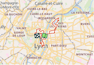

Length
17.7 km

Max alt
261 m

Uphill gradient
312 m
Km-Effort
22 km

Min alt
163 m

Downhill gradient
315 m
Boucle
Yes
Creation date :
2023-10-17 07:42:41.841
Updated on :
2023-10-17 16:02:24.24
8h18
Difficulty : Very difficult

FREE GPS app for hiking
 SityTrail
IGN / Geographical institutes
SityTrail Plus
The world is yours!
About
Trail Walking of 17.7 km to be discovered at Auvergne-Rhône-Alpes, Métropole de Lyon, Lyon. This trail is proposed by Jack-94.
Positioning
Country:
France
Region :
Auvergne-Rhône-Alpes
Department/Province :
Métropole de Lyon
Municipality :
Lyon
Location:
Lyon 2e Arrondissement
Start:(Dec)
Start:(UTM)
642495 ; 5069198 (31T) N.
Comments