


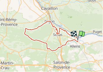
activity_mallemort_eygaliere_eyguieres_mallemort_2Wtj1V5lttqMCe67G7P69zlhBaO (3)

chris13370
User

Length
63 km

Max alt
278 m

Uphill gradient
535 m
Km-Effort
70 km

Min alt
83 m

Downhill gradient
535 m
Boucle
Yes
Creation date :
2023-10-17 16:06:56.034
Updated on :
2023-10-17 16:19:49.701
4h14
Difficulty : Very difficult
3h20
Difficulty : Very easy

FREE GPS app for hiking
 SityTrail
IGN / Geographical institutes
SityTrail Plus
The world is yours!
About
Trail Road bike of 63 km to be discovered at Provence-Alpes-Côte d'Azur, Bouches-du-Rhône, Mallemort. This trail is proposed by chris13370.
Description
Assez facile
Très beaux paysage entre Eygalières et Eyguières
Positioning
Country:
France
Region :
Provence-Alpes-Côte d'Azur
Department/Province :
Bouches-du-Rhône
Municipality :
Mallemort
Location:
Unknown
Start:(Dec)
Start:(UTM)
675258 ; 4843631 (31T) N.
Comments