


2023-10-17_18h09m39_F12 1

LUTZMarc
User
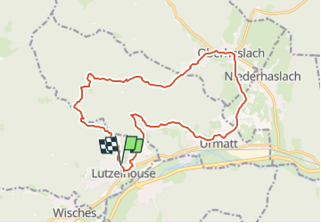

Length
17.1 km

Max alt
471 m

Uphill gradient
457 m
Km-Effort
23 km

Min alt
245 m

Downhill gradient
456 m
Boucle
Yes
Creation date :
2023-10-17 16:09:39.302
Updated on :
2024-11-01 09:08:09.708
5h16
Difficulty : Difficult

FREE GPS app for hiking
 SityTrail
IGN / Geographical institutes
SityTrail Plus
The world is yours!
About
Trail Walking of 17.1 km to be discovered at Grand Est, Bas-Rhin, Lutzelhouse. This trail is proposed by LUTZMarc.
Description
Départ raide.
Resto Le saint Florent à Oberhaslach.
Positioning
Country:
France
Region :
Grand Est
Department/Province :
Bas-Rhin
Municipality :
Lutzelhouse
Location:
Unknown
Start:(Dec)
Start:(UTM)
373531 ; 5375713 (32U) N.
Comments