


Circuit Frange Verte

Emelle
User
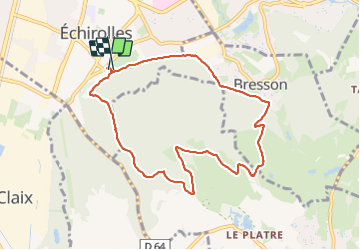

Length
8.9 km

Max alt
456 m

Uphill gradient
313 m
Km-Effort
13 km

Min alt
231 m

Downhill gradient
302 m
Boucle
Yes
Creation date :
2023-10-18 06:40:41.184
Updated on :
2023-10-18 09:21:53.299
2h23
Difficulty : Easy

FREE GPS app for hiking
 SityTrail
IGN / Geographical institutes
SityTrail Plus
The world is yours!
About
Trail Nordic walking of 8.9 km to be discovered at Auvergne-Rhône-Alpes, Isère, Échirolles. This trail is proposed by Emelle.
Positioning
Country:
France
Region :
Auvergne-Rhône-Alpes
Department/Province :
Isère
Municipality :
Échirolles
Location:
Unknown
Start:(Dec)
Start:(UTM)
713967 ; 5002018 (31T) N.
Comments